Environmental Justice Dashboards & Publications
The following content is used as educational material in the UIC Public Health Geographic Information Systems (PHGIS) Program at the School of Public Health, Health Policy and Administration Division. Case studies based on the COVID-19 pandemic help develop skills with learning outcomes in:
- spatial data analytic techniques (HPA 480 and HPA 565 online classes ) and
- the design of user comprehensible and friendly interactive dashboard and story maps (HPA 564, HPA 592, and HPA 455 classes).
The HPA 455 Geographic Information Systems Integrative Project online course is a major innovation of this educational certificate program. The primary objective of this class is to have our students interact with GIS experts and demonstrate their level of skills in applying database theories and GIS techniques to visualize and explore a public (or environmental) health issue such as the Covid-19 Pandemic. The story map platform is one of the educational platforms within which students interact with their instructor and gradually develop a story by analyzing and visualizing patterns.
The educational design, content, and tasks in the UIC PHGIS program were developed by (in alphabetical order): Matt Blaser, Michael Cailas, John Canar, Brian Cooper, Peter Geraci, Joel Hatch, and Kristin Osiecki.
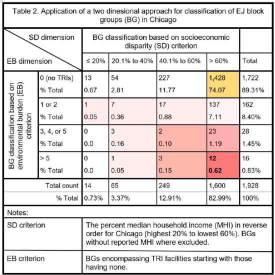
This demonstrates how policymakers may exacerbate environmental injustice in overburdened communities through a one-dimensional approach. (Taken from the submitted Policy Brief section of Journal of Environmental Justice. Under review.Putting the Environment back in “Environmental Justice”: A Two-Dimensional Approach for Area Identification.)